Ben Nevis Mountain Track and Glen Nevis
The Ben Nevis Mountain Track – also referred to as the ‘Pony Track’ or less poetic ‘Tourist Path’ – has its origins in the late 19th century and was actually never intended as a recreational route.
Constructed in 1883 to support the building and operation of the Ben Nevis summit observatory, the Track was designed to minimise steep ground for the ponies carrying coal, food and scientific equipment up to the weather station throughout the year. As such, it weaves a surprisingly accessible route to the high summit plateau, by way of a series of zig zags across Ben Nevis’ great bulk of grassy hillside and stony screes. The accumulative distance and ascent (and descent) offers a rewarding challenge.
Walk Summary:
- Distance: 10 miles / 16km
- Ascent: 1340m
- Time: 8 hours
- Start Point: Ben Nevis Visitor Centre
- Grid Ref: NN 122 730
Maps:
- Ordnance Survey: Explorer 392
- Harvey Maps: British Mountain Map – Ben Nevis & Glen Coe
Getting to the start:
Ben Nevis Visitor Centre offers an accessible and obvious place to start your hike to Ben Nevis’ summit. Arrival by bus or car from Fort William is easy and only 2 miles from the town centre, with the route signposted from Fort William to ‘Glen Nevis’. For sat nav, you’re heading to: Visitor Centre, Glen Nevis, Fort William PH33 6ST
A local bus company, Shiel buses can be used for getting in and out of Fort William and the N41 bus will take you up to the Ben Nevis Visitor Centre.
Read our Getting to Ben Nevis guide for more options, including travelling by train (a scenic and eco-friendly option!) and coach.
We recommend popping into the Visitor Centre within the car park area is always useful to gain updated information about the mountain, your Mountain Path route, ground conditions on the summit and the forecasted weather for the day.

Starting the walk
1. Keeping the Visitor Centre on your right, use the well-engineered path by the side of the River Nevis to reach a modern bridge. Use this to cross the River and turn right on to another good walking track, keeping the river now on your right.
2. After 100m or so, turn left alongside a wall, crossing (initially) flat fields to access a higher path, which is your gateway to the lower part of the mountain.
3. Turn right on to this path, which now ascends across the lower slopes of Meall an-t Suidhe.
In Scottish Gaelic , ‘Meall an-t Suidhe’ translates as ‘hill of the seat’ or ‘hill of the rest’, and its lower elevation does indeed give a good resting place before the higher slopes of Ben Nevis are reached!
4. Now on the start of your ascent across the hillside, the very well-engineered lower track carves its way across these lower slopes, crossing numerous smalls burns (streams) and continues to climb for another 2.5km, gaining an impressive 580m quite steadily towards the ‘seat’ of Meall an-t Suidhe area.
The views from this section of path extend south along the base of Glen Nevis, with its grazing areas and native woodland as well as forest plantations, towards the peaks of Sgurr a Mhaim (‘rocky peak of the rounded hill’) and Stob Ban (“White Peak” or “Light-Coloured Peak).
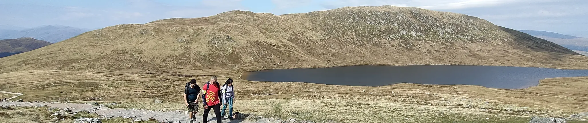
Just above the 550m contour, the angle of the slope eases and walking becomes easier as you bypass the water of Lochan Meall an-t Suidhe sitting in a dip between the summit of Meall an-t Suidhe and Ben Nevis’ rockier slopes higher up.
5. Just above 600m (a little under half-way up the height of Ben Nevis) the stony path reaches a junction where you turn right towards a larger stream, Allt na h-Urchaire (the Red Burn).
From this junction, looking up to the way ahead it’s easy to see how Ben Nevis came to get its name. From the Scottish Gaelic “Beinn Nibheis”, the name can be translated either as the ‘malicious’ or ‘venomous’ mountain or – less ominously – from “Beinn Neamh-bhathais”, a mountain with the top of its ‘head in the clouds’.
Most usually, when looking up at the vast west-facing slopes of Ben Nevis, cloud will obscure the higher section of mountain: the angle of viewing means you can never see the top until you’ve reached the summit plateau itself – all adding to the mystery!
Immerse yourself in your Ben Nevis experience with an expert-led walk. Find out more »
6. Above Lochan Meall an-t Suidhe, the path becomes a little rockier and soon crosses the Red Burn, which requires some care, but uses a well-walked crossing point.
7. Now the Mountain Path takes on another character as it makes progress upwards via large ‘switch-backs’ across the slope, turning quite sharply at rocky corners.
8. Once you’ve crossed the Red Burn there are eight more corners above you. Initially the route between each corner is quite long (the longest being apx 500m) and then, as more height is gained, the sections of rocky path become shorter, and steeper, until you reach the 1200m contour.
9. Once you’ve turned the ‘8th corner’, you’ll reach a stone cairn which marks the point the route takes a more direct line ESE towards the summit plateau.
In Scotland, a cairn is a human-made pile of stones, traditionally built to mark summits, routes, or important places in the landscape. On hills and mountains, cairns often help walkers navigate in poor visibility and have long cultural roots linked to remembrance and wayfinding.
10. Pass through a steeper section (which can hold on to winter/spring snows well until the summer months) called ‘McLean’s Steep’ at apx 1300m height.

This section is named after the Fort William-based engineer contracted to build the initial ‘Pony Track’ to the summit observatory, James McLean.
11. From here, it’s apx 600m distance to the summit, and the angle of slope becomes much flatter, over rocky ground.
On your final approach to the summit, the route bypasses the top of two famous gullies of Ben Nevis – Tower Gully and Gardyloo Gully on your left. They are used by Ben Nevis winter climbers, and if there is snow lying at the top of these gullies, keep well away from their edges in case of any remaining corniced snow around their rims, which may be unstable.
Rather unromantically, Gardyloo Gully was so named by the summit meteorological observatory staff, who used the gully as a place to dispose of waste and rubbish during its operation from 1883 to 1904. The term “gardyloo” comes from the French gardez l’eau – “watch out for the water” – once shouted in 18th-century Edinburgh before chamber pots were emptied from windows.

You’ll see remains of the observatory on the summit area (old walls) and the large stone cairn with an emergency shelter built on top. There is also a separate summit cairn with ‘Trig Point’ denoting the highest point on the mountain – 1345m!
Views can be incredible from Ben Nevis on a clear day, including spying some of the mountain’s steep north face cliffs as well its slender, radiating ridge called Carn Mor Dearg Arete, which connects Ben Nevis to the mountains, Carn Beag Dearg and Carn Mor Dearg, on the opposite side of Coire Leis below.
13. Retreating from the summit of Ben Nevis will take you down the same route as you came up, although the descent can be challenging in itself – you are definitely only half-way through your journey and effort expenditure.
14. In poor weather, take care to navigate away from the summit plateau in a SW direction for 150m (exact grid bearing is 231 degrees) to avoid the tops of steep gullies and arrive at the three large stone cairns, which mark where the route switches to an WNW direction (exact grid-bearing is 282 degrees).
15. Following this direction for 1km, and down through the steepening of McLean’s Steep, brings you back towards the cairn marking the top of the Mountain Track zig zags at 1200m.
16. At this cairn, turn right to now follow the Mountain Track in reverse, down to the lochan below Meall an-t Suidhe and continuing back to Glen Nevis and the Ben Nevis Visitor Centre.
For some the descent can take just as long, if not longer, than the ascent – so make sure you have packed enough food and drink to last for your way UP and your way DOWN the highest mountain in the UK!
Further reading:
- Find somewhere to rest your weary legs after your hike, with our Ben Nevis accommodation guide »
- Read our sister company, RAW Adventures’ Guide to Ben Nevis for Beginners »
- Find out what climbing Ben Nevis is like at different times of the year »
- Make sure you’ve got the right kit: check out our Essential Kit Guide »
Ben Nevis – Your Way
We run regular guided walks on Ben Nevis giving you the chance to join a small, friendly group led by an experienced Mountain Leader. All of our open dates are guaranteed to run, whatever the group size – take a look at our upcoming dates to find one that works for you.
If you’d prefer a more personal experience, you can also book a private guided walk. Whether you’re climbing with friends, family or colleagues, one of our Mountain Leaders can tailor the day to your group, pace and goals.
We’re also long-standing providers of charity Ben Nevis climbs, supporting individuals and groups to raise money for good causes since 2010. Over the years, our walkers have raised thousands of pounds for both local and national charities. If you’re looking to add purpose to your climb, we can connect you with one of our Charity Partners or support your fundraising for a charity of your choice.
Questions?
We’re here to help – get in touch with our team for all your Ben Nevis questions.